About
Site Directory
Copyright © 2025 www.isleofman.com
All Right Reserved
powered by ![]()
Copyright © 2025 www.isleofman.com
All Right Reserved
powered by ![]()
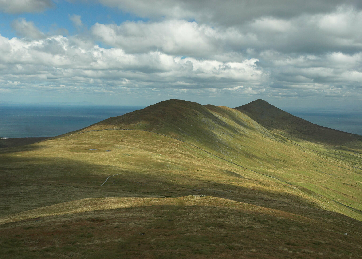
The Isle of Man's second highest peak, North Barrule, is located in the north of the Island
North Barrule is located in the north of the Isle of Man, to the north-east of Snaefell. It is the Island's second highest peak, with the summit standing at a height of 1842 feet above sea level.
For an ascent from the east side, access is by car via the A18 Mountain Road; it is approximately a 25 minute journey from Douglas or 10 minutes from Ramsey. There is a small parking area at the site known as the 'Black Hut', with the signposted footpath a short distance across the road.
For an ascent of its western face, take the A2 coast road from Douglas to Ramsey and stop at 'the Hibernia' (2-3 minutes' drive north from Glen Mona Hotel). There is a signposted footpath at the roadside. This road is served by a bus route and it is also possible to use the Manx Electric Railway service, although the nearest stop - Ballaglass - leaves you 20-25 minutes' walk away from the Hibernia.
Height Above Sea Level: 1842 feet
OS Grid Reference: SC4591
From the Black Hut, the walker must first ascend the peak of Clagh Ouyr, a short climb which should take no more than 20 minutes to complete. From there, it is a moderate walk along the ridge of hills to the summit of North Barrule. For a walker of average fitness, and at a leisurely pace, it should be a walk of approximately 1.5 - 2 hours. The terrain comprises mostly short, tussocky grass and is marshy in places.
From the Hibernia, follow the footpath signs up the tarmac road until it leads off the road and onto a rough track which winds steadily upwards to the left of the summit, between farm fields. Follow the track round for 40-50 minutes until you are facing the south slopes, above the Corrany Valley (it is also possible to make a longer ascent from the valley floor - turn off the A2 at the foot of the steep hill immediately after Dhoon Village; The Corrany is signposted). Begin to climb up through the fields, passing a ruined farmstead called Park Llewellyn on your left. A vertical dry stone wall winds upwards to the right, guiding towards the summit. Follow this until you meet the ridge path from Clagh Ouyr; after this, the path to the summit is clear. This route offers a shorter but more demanding walk.
The views from the summit are worth the effort and easily rival those of Snaefell, for instance one can see, on a clear day, the coastlines of Ireland, Cumbria, Wales and Scotland, as well as all parts of the Isle of Man not obscured by their proximity to the central range of hills.
Suggested Onward Routes for the Walker
Descend the south-facing slopes and explore the Corrany Valley, or retrace your steps along the ridge of the hill and walk in a horseshoe around the top of the Valley, parallel to the peaks of Slieau Lhean and Slieau Ouyr, then descend either to Glen Mona (meeting the A2) or, by going south over the top of Slieau Lhean, join the Agneash Valley.
The most notable incident relating to North Barrule is a tragic air disaster - the worst in the Island's history. On 23rd April, 1945 - only weeks before the end of the war - a B17G carrying 31 American airmen and captained by Charles E Ackerman was flying towards Northern Ireland for a period of recuperation. In thick hill fog, it crashed into the southern slopes of the hill, killing everyone on board. A plaque to commemorate the crew was laid by the Manx Aviation Preservation Society in 1995.